How to Use Autel Drones for DIY Aerial Mapping
Aerial mapping no longer requires a massive budget or a complex flight plan. Autel drones are democratizing aerial photogrammetry with accessible, high-performance tools for surveyors, landowners, and contractors.
Getting Started with Autel Mapping:
-
Use the Autel EVO II Pro RTK V3 for high-accuracy geotagging
-
Pair with mapping software like Pix4D or DroneDeploy
-
Set automated flight paths using Autel Explorer app
Key Benefits:
-
RTK module = centimeter-level precision
-
1-inch CMOS sensor = crisp imaging
-
40-min flight time = larger coverage in fewer passes
Real-World Use Cases:
-
DIY subdivision planning
-
Land development cost estimation
-
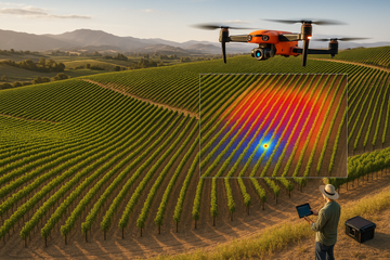
Crop canopy height modeling
Autel drones make mapping not only possible—but efficient, affordable, and highly accurate for anyone willing to learn.